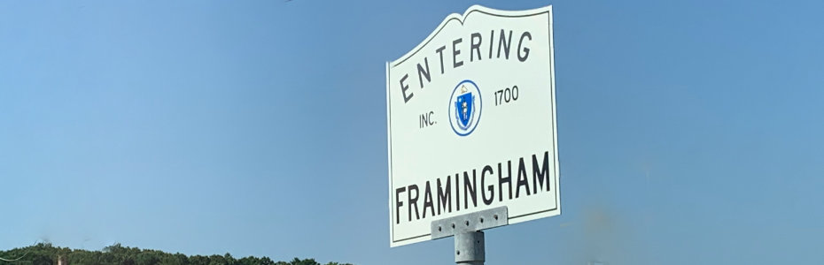
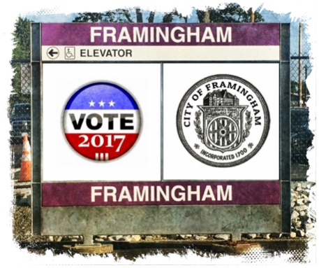
Framingham 2017 Mayor Election
The Town of Framingham will have it's first Mayor election on September 26, 2017. There are 6 candidates that are meet the qualifications to be the first Mayor of the city of Framingham. The top two winners in the September primary will face off for the November election.
Here's a list of the candidates and a link to their official websites:
- Josh Horrigan - "We, as a people, Have decided to Change. Now let's commit to it."
- John Stefanini - "We need to bring government to people, rather than people to government."
- Dhruba Sen - "My vision is to make Framingham one of the top 5 Smart Cities of the world."
- Mark Tilden - "There's no reason a major part of the marathon route which appears on the national stage each year shouldn't stand out as a bustling hub of our growing city. "
- Yvonne Spicer - "I'm running for Mayor to build our new city government in a way that is open and accessible to everyone."
- Ben Neves-Grigg - "Ben's vision is to move the City of Framingham forward as the most desirable city in the Commonwealth."
- Priscila Sousa - "will govern to provide a voice for those who have become disenfranchised by the status quo."
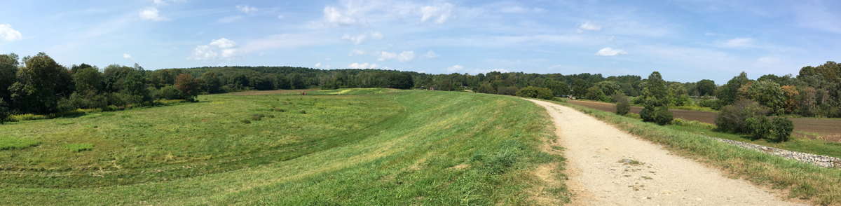
Callahan State Park
Framingham's Callahan State Park is a public recreation area covering 958 acres. People use the park for hiking, Mountain Biking, Fishing, horseback riding and walking. There is a pond where dogs can play in a beach like area.
The park has many trials with various main entrances:
- North Entrance - Good place to start on the Hiking trails. Lots of available parking.
- Edman's Road Entrance - Nice lot
- South Entrance - Primary Dog entrance. Enjoy the pond and meet other dog owners. Watch out for Golfers across the street when parking!
This is a nice park where there is a combination of open fields and woods. There's all sorts of fun trails to explore.
Not only is this a fun place to go for a walk, but its a fun place to bring your camera and take pictures - especially in early October.
You don't need a dog to visit the park - as there are lots of trails to explore. During a recent visit we encountered several families out for a nice Labor Day walk.
Ten things I Learned About Callahan State Park
- Officially Became a State Park in 1970
- Named after Raymond J, Callahan, an editor of the Framingham News. The park was named after him shortly after he died in 1969.
- Was a farm land since 1699 and 425-arces was turned over to the state as park land in 1969. The state paid $322,500 for the land. The state was buying lots of open space and some people didn't think it was a good use of the state's money.
- The park now encompasses 958-arces. (I wasn't able to find out specifically when the park expanded in size.)
- When the park first opened, there were personal aircraft shows near the Millwood entrance. Over a 1,000 people showed up. (Where did they park?)
- Dog owners should be careful about having their dogs swim or drink at the pond off Millwood Street. There are bacteria in the water since it is still water. Probably not a good idea to have puppies play in the water.
- One of the few places in the MetroWest where you can take dogs off the leach. Make sure to read the park signs, this is not a 100% leach free area and park rangers have been known to enforce the rules. Make sure you are in control of your dog at all times.
- Learn about the trails before you go. There are trail maps available if you need it.
- There is only 30 parking spaces on the Millwood Ave parking lot. This tends to fill up quickly on Weekends because its very close to the leach free area and pond. Cars will line the streets near the parking lot entrance.
- If you plan to visit the park with your dog frequently, consider joining the Callahan Dog Owners Group. It's a group that is working to make Callahan State Park the best multi-use park in Massachusetts.
Official Street Address
The park offical street address is 1048 Edmands Rd, Framingham, MA 01701. If you are bringing a dog visit the Millwood entrance as you'll see other dogs enjoying the open field.
PermalinkCurbside Refuse Collection Planner
Framingham residents will soon be dusting off their rakes and leaf blowers. Pretty soon leaves will be falling down on lawns all over town.
It's important to know when the town will come by and pick up the Lawn/Leaf bags.
Note: the paper bags aren't strong enough for many re-uses. It's pretty safe to use it a couple of times, after that, you take a chance of the bags opening up in the car. This is especially true if you have wet leaves.
Here's the Town of Framingham Curbside Collection for September 2017 - to January 2018:
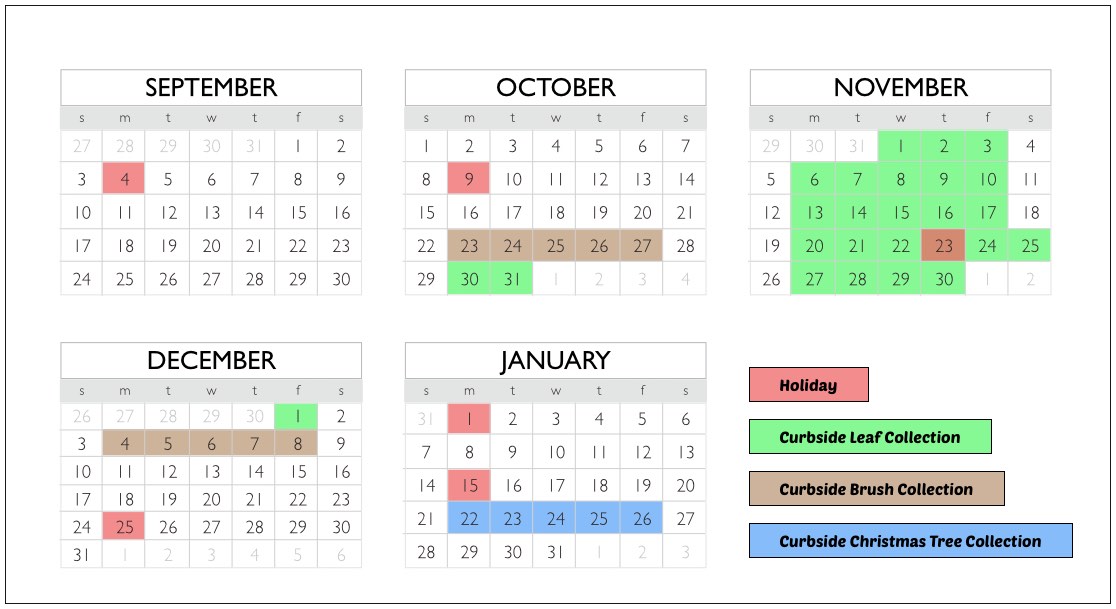
Click on image for a larger version.
I recommend saving a copy of the graphic and display it near where you keep trash bags. Basically, remember that when you put out the trash in November to also put out leaf bags.
PermalinkFramingham's Old Colony Hotel
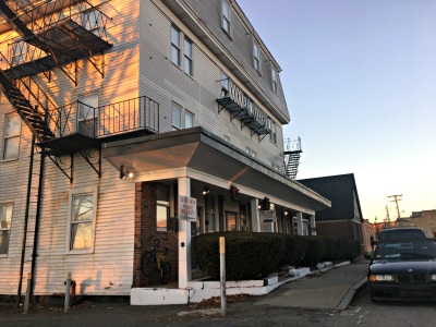
The Old Colony Hotel is a small hotel near downtown Framingham. Framingham MBTA commuters may see the hotel as they drive to the commuter rail parking lot, as it's the last business before the parking lot.
Some online reports claim that the hotel was built around 1885. However, the town of Framingham lists the building as being built in 1900.
50 Year old Murder in Framingham
According to local reports In April 1966, John T. Horning murdered James Barry Sr. at a bar at the Old Colony Hotel. Police said that his motive for the killing was that John wanted to collect money that James owed him. John confronted James in the men's room, a fight broke out and James ended up on the floor with a broken neck.
James Barry Sr., age 66, died a few hours later at a local hospital from the neck wound.
John T. Horning, then 26, was charged with the murder. There is no information on the status of the trial, beyond that the jury visited the hotel to see the crime scene.
Here are some other things that I have learned about the hotel:
Interesting Facts about the Old Colony Hotel
- Built in 1900, but the sign on the hotel says it's established in 1885
- There are 24 bedrooms in the hotel
- The hotel square footage is 11,677 sqf
- The building is worth more than the land. (Building: $1,095,900 and Land: $155,100)
- The Hotel was built across from the railroad depot as a place to people to stay when they arrive to Framingham via rail.
- Was once called the Park Central Hotel and the Park Haven Hotel.
- Apparently the name of the hotel changed between Park Haven and Old Colony over the years.
- A Boston Globe report stated owners of the Old Colony Hotel were going on a cruise in 1920, and then a few years later articles talk about events at the Park Haven Hotel.
- Hotel was own by Frank E. Brooks until his death on July 30, 1926. He left the hotel to his son Frank H Brooks.
- Frank H. Brooks attempted to sell the hotel in an ad in the Boston Globe April 23, 1944.
- There were two fires at the hotel: November 24, 1946 and sometime in 1959.
- The fire in 1946 started at the Grain Elevator next door caused significant damage to the hotel.
- Murder Occurred at the Hotel in 1966, A Middlesex County Superior Court jury visited the hotel on April 25, 1966.
- Hotel went under foreclosure auction on September 21, 1975
Location
The Old Colony Hotel is located at 2 Franklin St, Framingham, MA 01702
PermalinkFramingham Airports
Did you know that the town of Framingham once had 2 airports. Between 1920 and 1942, there were two airfields in Framingham. The field names were State Musterfield and Gould Airport.
State Musterfield - 1920 - 1931
- Airport was located between Massachusetts Emergency Management Agency (MEMA) and Fuller Middle School
- A heliport serving the Massachusetts State Police Headquarters.
- There is a monument at the State Police Headquarters for those that served in the First World War.
- The airport was for government use only.
- The most notable event happened in October, 1921, when it became the first landing point for Airmail in New England. (Washington DC -> Framingham)
- Airport was in service between 1920 and 1931.
- Airport stopped operating after the town tried to buy the land from the state.
Gould Airport - 1930 - 1942
- Located on Western Ave. near the location of the ADESA (Auto Auction Dealer)
- Located on Gould Farm
- Dedicated on November 8-9, 1930
- 10,000 people attended the dedication
- It was at the dedication where many people from Massachusetts got their first experience being in an airplane.
- 2,800-foot Runway (North and South)
- 1,500-foot Runway (East and West)
- The airfield was force to close in 1942 because of World War 2 as All civilian airfields within 25 miles of the coast were forced to cease operations.
- After the war, the town were in the plans to buy the land to make it a municipal airport, but were side-step when Teddy Gould sold the land to General Motors.
Last Aviation Death in Framingham
This Christmas marks the 80th anniversary of the last person to die at the Framingham Airport (Gould Airport). Lloyd George Wallace (age 21) died while flying his plane on December 25, 1936.
According to various news reports at the time:
On Christmas Morning Lloyd Wallace went out on his airplane and flew over his parent's house (21 Speen Street, Natick MA). He waved to his family and friends who were at the house. After spending a few hours flying around, he returned to the airport, drove to his parent's house and enjoyed a Christmas meal.
After dinner, he returned to his airplane for another flight. However, shortly after takeoff, the plane went into a tailspin at 100 feet in the air. The plane crashed to the ground near the airport. He was taken to the Framingham Union Hospital where he was pronounced dead.
Further investigation found that the cause of the crash might have been low fuel. As the plane was going higher in altitude, gravity was preventing the low fuel from going into the engine.
Lloyd George Wallace was buried at Pine Hill Cemetery in Sherborn Massachusetts.
PermalinkWinter Street Bridge
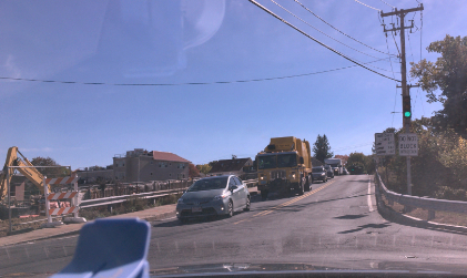
The Winter Street Bridge in Framingham, Massachusetts is set to close so that a new bridge can be installed. The new bridge is scheduled to be completed by September 2017, just in time for the new school year.
The bridge handles about 8,000 cars a day, according to a traffic count done last April.
Most of the people that use the bridge come are coming from Ashland and are heading towards Route 9. Some popular places are Joseph P. Keefe Regional Technical High School, and Framingham's Barbieri Elementary School and Framingham State University.
The new bridge will be wider than the current bridge, which will allow for turning lanes at the Waverly and Fountain Street intersections. The goal of the new bridge will be to reduce traffic congestion at Winter Street???s intersections with Fountain Street and Waverly Street.
A pedestrian access will be maintained throughout the project.
Accelerated Bridge Program
The MassDOT Accelerated Bride Program is a major infrastructure investment to fix all the high-risk bridges in the Commonwealth of Massachusetts. Through October 1, 2016 the MassDOT Accelerated Bridge Program has advertised 200 construction contracts with a combined construction budget valued at $2.45 billion.
According to the active project listing provided by the MassDOT the Bid amount for this project is $6,649,130. The Construction Contractor for this project is Northern Construction Service, LLC.
The original plans, from MassDOT, had the bridge to be closed 14 months from June 2015 to Aug. 2016. The project was delayed due to planning issues - including work on another bridge on Winter Street.
Alternative Routes
Fountain Street will see an increase in traffic. Drivers from Ashland will be better off using the Fountain Street exit on 135, near the Best Friends Pet Care. Drivers from Downtown Framingham would be best to use Fountain Street, near the Ron's Tire and Service and Walgreens.
Both of these routes will make avoiding the traffic around Winter Street a bit easier.
Winter Street Bridge 2013
On June 10, 2013, the Winter Street Bridge over the Sudbury River closed for repairs. This was the first time in 83 years that the road was closed to repair that bridge.
PermalinkShopper's World Track
On Sunday morning, while waiting in front of Toy R Us, we saw a person running around the Framingham Shopper's World parking lot several times. That got us wondering what is the total distance running around the parking lot.
Thanks to Google Maps, I was able to figure it out:
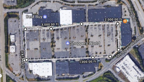
Thanks to Google Maps for the measurement.
Total area: 740,366.42 ft (68,782.29 m)
Total distance: 3,873.50 ft (1.18 km) or (.73 Miles)
If you were doing a 5k, you would need to run a little more than 4 times around the parking lot. The good thing about this is that the parking lot is very flat. The bad part about organizing a 5k here is that you would need a lot of barriers to prevent people from cutting across the parking lot.
That guy that was running, he kept a really good pace, and to be up before the crack of dawn...well that's dedication.
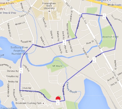
Better 5K Location
If you're planning a 5K race in Framingham, the better place would be near the Cushing Memorial Park.
The race would start on Dr. Harvey L Cushing Way and the runners would head towards Winter Street. The would take a right on Winter and head down over the river and then a right on Maple Street. At the end of the street, they would take a left on Franklin St, then a right on Maple Street. At the end of the street, they would pass by the Minutemen Monument and down Main Street, then a right onto Walnut Street. After passing Bowditch Field they take a right on to Mount Wayte Ave and head back to the parking lot at Cushing Park.
This is a standard 5k route and it's a pretty much level field, with some elevation on Mount Wayte and Winter Street.
Here's a map of the route:
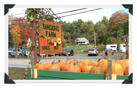
Hanson Farm
In the early days of Framingham, there were many farms all over the town. There were so many that every year there was an agricultural fair where farmers could showcase thier crops.
According to the current Framingham town records,, there are now two active farms in the town of Framingham. The town remaining farms are Hansons Farm and Stearns Farm. The two farms are practically neighbors located near Callahan State Park.
The two farms are on land that was once part of Danforth Farms - the first farm of Framingham.
Hansons Farm Pumpkin Picking
Last month we took a ride over to Hanson's Farm to get some pumpkins. Usually we venture over to Stow and get some pumpkins at Derby Ridge Farm or Shelburne Farm.
We were lucky that there weren't that many people at the farm. We parked across the street and walked over to the farm stand.
Bring your Camera and Creativity
In front of the farm stand there are all sorts of fall displays - perfect as a background for fall pictures. There was an old tractor where kids can pretend they are riding it while Mom and Dad take pictures.
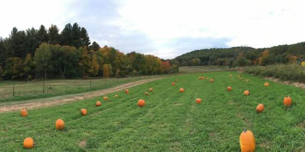
At the pumpkin patch, there is a large field with the Callahan State Park in the background. This is a great place to take fall pictures. Occasionally you'll see
At the first pumpkin patch is an oversize pumpkin where kids can go in and parents can take a picture to remember the day. Come back every year and you can see how much the kids have grown.
Pumpkin Patch
The pumpkin patch is a short walk from the farm stand to the field with all sorts of Pumpkins. Make sure to bring one of the red wagons - you'll need it.
There are a lot of pumpkins to select from. We found that it was best to keep the red wagon in the middle of the field until we found the perfect pumpkin.
In 2016, the pumpkins cost $.69 a pound. They had Cheese, Large, Cinderella, Goosebump, Mini and Batwing Pumpkins. You could buy quality Cornstalks, Hay bales and Indian Corn for awesome home fall displays.
Fun Facts that I learned about the Hansons Farm
- Hanson's Farm is a 5th Generation Farm located at 20 Nixon Rd. in Framingham, Mass. They grow 52 acres of Fruit and Vegetables and over 100 acres of Hay.
- The actual farm building is on 23.19 acres, but the Hanson Family owns a lot of the surrounding land.
- Open since 1913 (When it became Hansons Farm, prior to that it was known as Child's Family Farm)
- According to the Framingham town records, the Farm House was built in 1760. Think about that the next time you visit the farm. The house is 256 years old!
- The Hanson Farm is the oldest continuing operating farm in Framingham.
- On Friday/Saturday nights in October, they get transformed to Hanson's Haunted Farms from 7pm to 10pm
- They have Strawberries picking in June and July.
- You can get fresh cut flowers from Mid-June to the first frost. (A special treat for someone!)
- Pumpkins are ready from September to November.
- The Farmstand is open from May 15th to November 1st. (170 Days)
Center of Framingham
Where is the exact center of Framingham? How is it calculated?
According to various historic records, the Framingham Center green, where the town commons is located, is the physical center of town. I wanted to see if that was the case.
There are different methods to find the exact center of a city/town because there is no official definition. For many small towns, it has a certain meaning: they can leave their anonymity and can build a monument.
Geographical Center of a Town
Obviously the physical center of gravity is seen as the geographical center of an area. This can easily found by cutting out the town map on a piece of paper and then trying to get it to balance on a pencil.
Using the Circular Method
Using the Circular Method is an easy way to find the center of a location. You simply draw a circle around the outer points of the town, and then find the center of the circle.
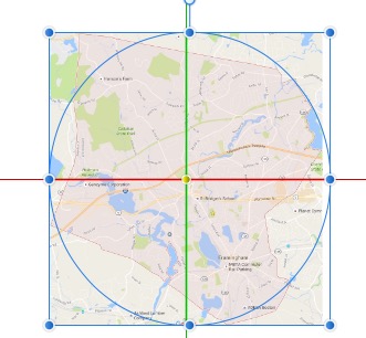
Using the Circle Method is one way to find the center of a town. Using Affinity Designer is an easy way to pinpoint the center of the circle.
Using this method, with the help of Affinity Designer, I was able to determine that 53 Grove ST, Framingham MA appears to be the center of the town. This is the site of the Edgell Grove Cemetery.
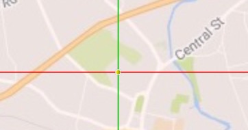
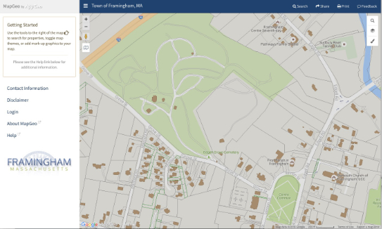
Map Geo Confirmed!
If you visit Framingham's MapGeo, by AppGeo, and zoom in you'll land at the same location in the Edgell Grove Cemetery. This is because when the site opens to the view of the entire town when you zoom in, you zoom to the center of town.
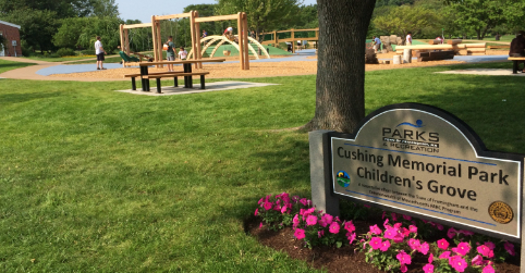
Cushing Memorial Park Children's Grove
Cushing Memorial Park, formerly called Tercentennial Park, is a 57-arces open park on the site of a WWII army hospital. The park features open space & trails and a chapel. There are several Framingham Park buildings where some ???Playgroup Program" classes are held.
Over the past few years there has been attempts to improve the park. There is a master plan where the Parks and Recreation Department has a clear strategy to improve the park. The town has added:
- Phase 1 - Construction of new lighted parking area near the Chapel, new gardens around the chapel
- Phase 2 - New park entrance near Keefe Tech new parking at the southern edge of the park.
- Phase 3 - Reconstruction of major pedestrian corridors near Barbieri School. New Entrance by Winter Street
- Phase 4 - Reconstruction of major pedestrian corridors near Winter Street. New pergola seating area with park history
- Phase 5 - Added a new Playground: Cushing Memorial Park Children's Grove. (Officially Opened July 8, 2015)
Phase 5 Improvements
In 2014 there was a sign near the new playground that read:
The Parks and Recreation Department recently received a $400,000 Parkland Acquisitions and Renovations for Communities (PARC) grant to implement Phase 5 improvements at Cushing Memorial Park.
Approved Phase 5 concept plans create a naturally themed gathering area for park patrons which will include picnic amenities, a children's grove with formal and informal play equipment, ADA accessible pathways, formal landscape plantings, tree plantings and continued installation of hardscape features including benches, signage and ground surface treatments.
Final Design is currently underway with construction targeted to begin during July of 2014 with completion in the late spring of 2015.
Cushing Memorial Park Children's Grove Fun Facts
- Prior to the new playground, a Train play area and slide set was at the location.
- Playground cost $665,000
- Parks and Recreation Department won a $400,000 state grant from the Massachusetts Energy and Environmental Affairs agency to cover the cost.
- Playground is designed for children???s 5 to 12
- There is a water pump that is available for children to play with, it???s open from the Spring to Labor Day weekend.
- Picnic Tables were added so parents can socialize while the children play.
- Potentially there will be a serpentine pond with landscape banks across from the Cushing Memorial Park Children's Grove.
- Six Swings including an Adaptive Swing Seat which is ADA compliant (American Disabilies Act)
- Log Seasaw
- SuperNova 2 - Modern Day Spinning Wheel
- Loopy Whoop Spinner - Single person Merry-Go-Round
- Duet Musical Chimes by Freenotes Harmony Park Outdoor Musical Instruments.
Personal Thoughts
My five-year-old daughter likes the Cushing Memorial Park Children's Grove playground for a little bit. After a while of play, she shifts gears and would rather go over to the playground behind Barbieri Elementary School.
She likes the large slide selection and the different play areas that are available. She feels that there isn???t that much to play at the Cushing Memorial Park Children???s Grove.
PermalinkAbout
Framingham is a city in the Commonwealth of Massachusetts. Every Tuesday I'll highlight something special about the city.
Check out all the blog posts.
Schedule
| Thursday | Gluten Free |
| Friday | Macintosh |
| Saturday | Internet Tools |
| Sunday | Open Topic |
| Monday | Media Monday |
| Tuesday | QA |
| Wednesday | New England |
Other Posts
- Edward F. Loring Ice Arena
- John Swift Dwelling House
- Christmas Gala Music Selection
- Peter Salem
- Curbside Refuse Collection Planner
- B. Sisters Cafe
- Framingham Dog Park
- Plastic Bag Reduction Ordinance
- Framlingham vs Framingham
- Saint Bridget School Auction
- Framingham Mayor Election
- Framingham Presidential Election Results
- Callahan State Park
- Framingham Recycle Center
- Bowditch Field