Framingham Presidential Election Results
Fresh off of Donald Trump win of the White House, I thought it would be interesting to see how Framingham performed against the actual winner of a major presidential election.
Framingham is clearly a blue town, at least that's what it has shown on every election result since 1972. The only year that the town went Republican was in 1984.
Here is a table highlighting how the town votes
| Year | Republican | Democrat | Actual Winner |
|---|---|---|---|
| 2016 | 7,031 | 20,277 | Donald J. Trump / Mike Pence (R) |
| 2012 | 8,938 | 18,340 | Barack Obama/ Joe Biden (D) |
| 2008 | 8,430 | 17,839 | Barack Obama / Joe Biden (D) |
| 2004 | 8,448 | 17,239 | George W. Bush / Richard Cheney (R) |
| 2000 | 7,347 | 17,308 | George W. Bush / Richard Cheney (R) |
| 1996 | 6,669 | 16,836 | Bill Clinton / Al Gore (D) |
| 1992 | 8,114 | 15,165 | Bill Clinton / Al Gore (D) |
| 1988 | 12,745 | 15,826 | George Bush / Dan Quayle (R) |
| 1984 | 15,074 | 14,368 | Ronald Reagan / George Bush (R) |
| 1980 | 11,979 | 12,275 | Ronald Reagan / George Bush (R) |
| 1976 | 13,903 | 15,387 | Jimmy Carter / Walter Mondale (D) |
| 1972 | 12,975 | 15,652 | Richard Nixon / Spiro Agnew (R) |
Data used in the above table came from the Massachusetts PD43+ Elections Statistics Database.
PermalinkCurbside Refuse Collection Planner
Its autumn time in New England. While the color on the trees is delightful, may homeowners are frightful of having to do fall clean up.
In Framingham, there're only a few weeks out of the year where the Department of Public Works will pick up your bag leaves that you leave by the curb.
I created a quick reference guide to the various pickup schedules for November, December, and January. Once the 2017 schedule is published, I'll create a schedule for that.
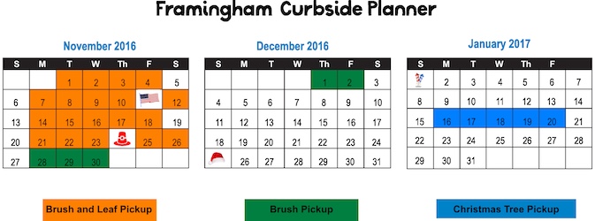
Click on image for a printable quality version of the schedule.
Some Notes about Curbside pickup
- Pickup start time is usually 7am, but I have found they tend to do the trash first, and then do leaves in the afternoon.
- All leaves must be in large paper bags. (Available at Stop and Shop, Lowes, Home Depot, Christmas Tree Shops and Monarch Supply)
- The bags must be crumble at the top.
- Place the bags near the edge of the road.
- Any major storms in November will impact the schedule, follow DPWFramingham on Twitter for the latest news.
Peter Salem
Black Revolutionary War hero that Died broke
In Colonial America, there were many fighters that fought for the freedom of this country. Among the farmers and tradesmen on the battle lines were black slaves who fought with the hopes of gaining their freedom.
One of the 5,000 blacks and free men who fought alongside the farmers and tradesmen was Peter Salem from Framingham, Massachusetts. For many years he was a slave to Captain Jeremiah Belknap. He was then sold to Major Lawson Buckminster. Just before the start of the Revolutionary War, Mr. Buckminster set Peter Salem free so he could enlist in the militia and fight in the American Revolution.
Bunker Hill
Peter Salem served under the Framingham militia and was part of Colonial Nixon's Regiment. At the battle of Bunker Hill, Peter was ordered to support Colonial Prescott. As the militia was faced with some difficulties, the British Major Pitcaurm, seeing victory was near, said: "The Day is Ours!" Peter Salem shot the Major, and Major Pitcaurm fell into the arms of his son. He would later die in a house in Boston.
The death of the British Major was an inspiration to the colonial militia and gave hope to those fighting for the American Revolution.
Life after the Revolutionary War
Peter stayed with the Framingham Militia throughout the war. He fought at various battles including Saratoga and Stony Point.
After the war ended, he headed to Leicester, Massachusetts. He lived in various parts of town where he did odd jobs including farming, making and mending baskets and fixing chairs.
Peter Salem didn't really do well in his business and resorted in support from the local government. The town of Leicester sent him back to Framingham where Peter lived his final days in a poor house.
Peter Salem died on August 16, 1816. He was buried at the Church Hill Cemetery (Old Burial Grounds) in Framingham, not far from the Belknap and Buckminster farms where he served as a slave.
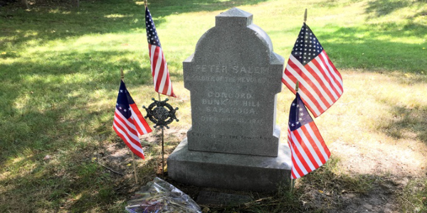
Grave at Old Burying Grounds
Since he had no money, Peter Salem was buried in an unmarked grave at the Old Burying Grounds. In 1882, the town of Framingham spent $150 to honor Peter Salem with a monument. (Equivalent to $3,488.37 in 2016)
Note: No one knows exactly where Peter Salem body was buried. The monument was placed in the center of an area where unmarked graves were kept.
Tips on finding the monument at Old Burial Ground:
- There is no parking in front of the graveyard, the nearest public parking is over by Bowditch Field by Walnut Street.
- At the main entrance, near the "Old Burying Grounds Cemetery" sign on one of the stone post, walk the main path all the way to the back.
- There is a small grass area, in the middle of the grass is Peter Salem monument.
- You'll see an American Flag and a Revolutionary Star next to the monument.
- There are 89 Revolutionary Solders that are also buried here, look for the Revolutionary Star to the left of their headstone.
- Major Lawson Buckminster, Peter Salem's former owner, is also buried at the Old Burial Grounds.
Battle of Bunker Hill Painting
At the Boston Museum of Fine Arts is a painting of the Bunker Hill, called "The Death of General Warren at the Battle of Bunker Hill." In the painting, you can see a black man standing behind Joseph Warren.
Many historians suspect that the painter, John Trumbull, had painted Peter Salem there as a tribute to his actions at the Battle of Bunker Hill.
Peter Salem Monument
In Leicenter, Massachusetts, there was a small memorial to Peter Salem at his former homestead. His last residence was on Rochdale Road. After he died, the road was renamed "Peter Salem Street."
For many years there was a small stone monument cemented together with the inscription, "Here Lived Peter Salem, Negro Solder of the Revolution." The monument disappeared many years ago. (45 Peter Salem Street is where I believe the monument was.)
Children that went to school in the area around Leicenter, Massachusetts learned all about their native hero. They learned all about how a former slave help the momentum of the militia.
Monument to Black Revolutionary War Soldiers
In 1985, the House of Representatives approved a bill to erect a monument to the black patriots who served under George Washington and Marquis de Lafayette. The Senate delayed the vote because of dispute of where the monument would be placed.
After 30 years, the National Park Service suggest a small strip of land near the Department of Agriculture, at the corner of 14th Street and Independence Avenue. President Obama signed the authorization into law on September 26, 2014.
The National Liberty Memorial is still gathering funds for the Memorial, visit their website for additional information.
PermalinkFramingham Salem Ends House
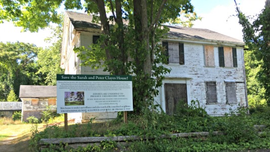
At 657 Salem End Road, in Framingham is the "Salem End" house. This ia an abandon house with history dating back more than 323 years ago.
History of the House
In 1692, it was the peak of the witch hunt in Salem, Massachusetts. Among all those being sought were three sisters who were accused of witchcraft: Sarah Towne, Rebecca Nurse, and Mary Esty. At the time it was widely believed that witchcraft was a family trait.
All were tried and evidently found guilty of witchcraft. Rebecca and Mary were hung within days of their trial. With the help of her husband Peter, Sarah escapes prison and was hidden by her family and friends until they reached Framingham, then called Danforth's farms.
Once in Framingham, Sarah changed her last name to Clayes. She lived the remaining years of her life trying to clear her sister names. She died in 1703. Sarah's grave has never been found. Framingham's oldest graveyard only has gravestones dated back to 1704. It's possible that Sarah might be buried in an unmarked grave in the cemetery.
Part of the downfall of the Witchcraft hunt was done by Deputy Governor Danforth as he was instrumental in stopping convictions by the court.
The area was name "Salem End" because of all the families who escaped the Salem Witch Trials more than 323 years ago. The families found that the area gave them peace from all the witchcraft delusion the occurred in Salem.
Over the Years
The house has changed hands many times over the years.
In the 1990's, the house was part of a bitter divorce and as a result, no care was taken to the house or property. The house has been officially abandoned for ten years.
In the 1980's when the house was for sale, someone placed a classified Ad, Here's the December 9, 1984, Boston Globe copy:
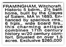
Sign at the House
If you drive by the house today, you'll see a large sign with the following text:
Save the Sarah and Peter Clayes House!
Elements of this house date back to 1693, when Sarah and Peter Clayes -- along with their extended families with surnames of Nurse, Bridges, and Esty - built their dwellings along what is now known as Salem End Road. This little group was refugees from the witch hysteria that gripped the home of Salem Village, 30 miles northeast of this spot. Sarah's sister Rebecca Nurse and Mary Esty were hung for witchcraft, along with 17 other men and women, and Sarah herself was jailed for the same fabricated crime. Sarah survived , and settled with her family on what was then known as Danforth's Farms, named for Thomas Danforth, who was Deputy Governor at the time. These early settlers went on to incorporate the Town of Framingham in 1700.
Efforts are underway to Preserve this historic home. If you would like to join this Initiative, please see our website at www.sarahclayeshouse.org
This home is under serveillance and also watched by concerned neighbors. Trespassing is not allowed and will be prosecuted.
Current Status
An onsite Auction was held on Oct 23, 2015, where the current owner, Goldman Sachs, had pledged to donate the house to a non-profit who would restore the house. They would only pledge if no one else wanted the house.
There were three potential bidders at the auction but none of them wanted the house at the opening bid of $817,894. The current Zillow value is $637,042. The house last sold for $224,973 in July 1997.
In December of 2015, Goldman Sachs made good on its promise and donated the house to the Sarah Clayes House Trust.
The Land Conservation Advocacy Trust is now working to raise money to help restore the house, you can visit their Go Fund Me campaign to contribute to saving the house. They are looking for tax-deductible contributions to raising the first $10,000 need to help save the house.
The Go Fund Me campaign has lots of information about the history of the house and the what the Trust plans to do with the house.
PermalinkPedestrians Track Crossing
The main MBTA commuter parking lot in Framingham is located at 2 Franklin Street. This lot is often called the Banana Lot because of its banana like shape. Because of its proximity to the commuter rail station, commuters have to cross a set of tracks to get to the inbound track boarding area.
Framingham Commuters did you know that there are a set of tracks that commuters are technically not allowed to cross? Last week Framingham Police were preventing commuters to cross the main set of railroad tracks.
Commuters are supposed to use the pedestrian overpass or cross the tracks at Concord Street. In Massachusetts, it's illegal to cross any railway tracks except at a designated crossing points.
MBTA Track Rules
Here is the Massachusetts General Law (Mass. Gen. Laws ch. 160, S 218):
Section 218. Whoever knowingly, without right is present, stands, walks, or rides a bicycle, snow vehicle, recreational or other vehicle on the right-of-way, bridge, or other property of, or used or controlled by any railroad corporation, except at a highway or other authorized grade crossing and except on rights-of-way formally abandoned pursuant to state or federal law and no longer owned by said railroad corporation or rights-of-way owned by said railroad corporation but which have been converted or leased specifically for use as a bicycle or walking path in accordance with state or federal laws, shall be fined $100 or shall be required to perform a total of 50 hours of community service which may include service in the operation lifesaver program, so-called. Any person violating this section may be arrested without a warrant by any police officer, including railroad police, and proceeded against according to law.
Operation LifeSaver is a non-profit organization that educates the public about rail safety. According to Operation LifeSaver, some trains can take a mile for to come to a complete stop. Remember that the tracks are used by freight and commuter rail.
Technically A Crossing Point?
There is a sign near the crossing which may indicate that it's safe to cross here:
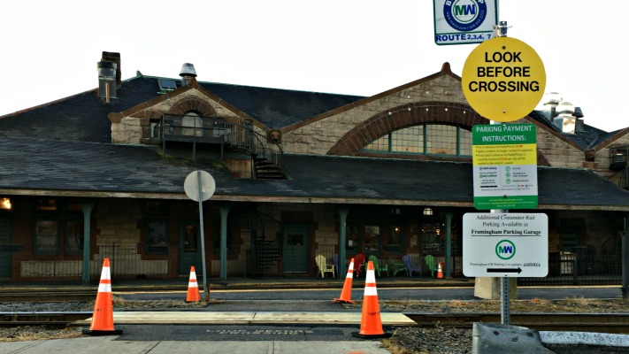
Since the sign is warning pedestrians to "Look before Crossing" it appears that this is a valid crossing point. However, the MBTA and CSX claims that only the first set of tracks is valid. (Which is why it has a wooden base) It's illegal to cross at the main set of tracks in front of the old station.
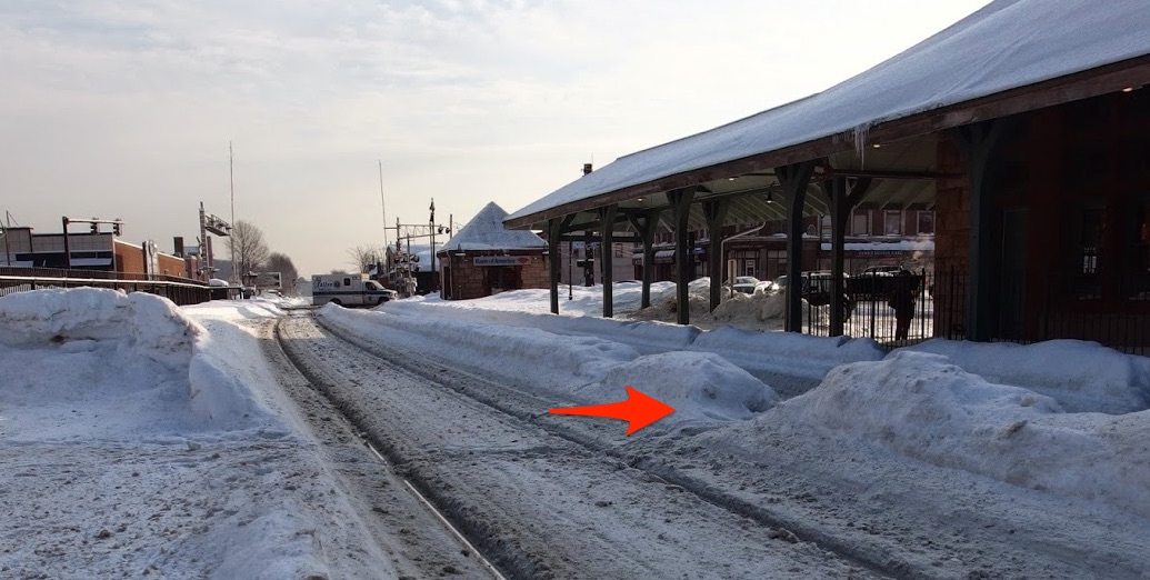
In the Winter, commuters cut across the tracks and leave a path in the snow pile for others.
Pedestrian Fence
For years, I assumed that the reason for the fence between the two main MBTA tracks was to discourage pedestrians from crossing the track at the station. I assumed that the fence stopped near Concord Street crossing as an indicator to pedestrians that it was safe to cross.
My assumption was mostly wrong, while the fence is there to prevent immediate crossing, pedestrians should never cross tracks when they have to step over the tracks and there's gravel on the ground. Proper crossing will always have a flat surface.
Why doesn't the fence go to the road?
According to the MBTA and CSX, the reason why the fence doesn't go all the way to Concord Street is because there isn't enough clearance for two trains and the fence. The tracks come closer together within a few yards of the street are closer. The MBTA and CSX say that it's too close to a fence.
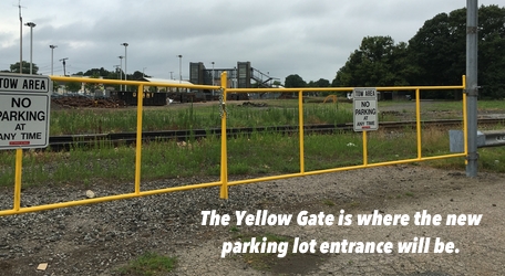
New Parking Lot Changes
When the new Framingham parking lot opens in the Spring of 2017, the existing entrance to the train tracks near the Deluxe Depot Diner will be closed. Commuters will have to use the new entrance by the pedestrian overpass to get to train station.
The new entrance is good news for the commuters that park at the Pearl Street Garage since the walk to the station will be a slightly shorter. This is bad news for those that are waiting for the MWRTA bus and wanting to get a drink at Tedeschi Food Shop, or go to the ATM - those people will have to use the Concord Street crossing.
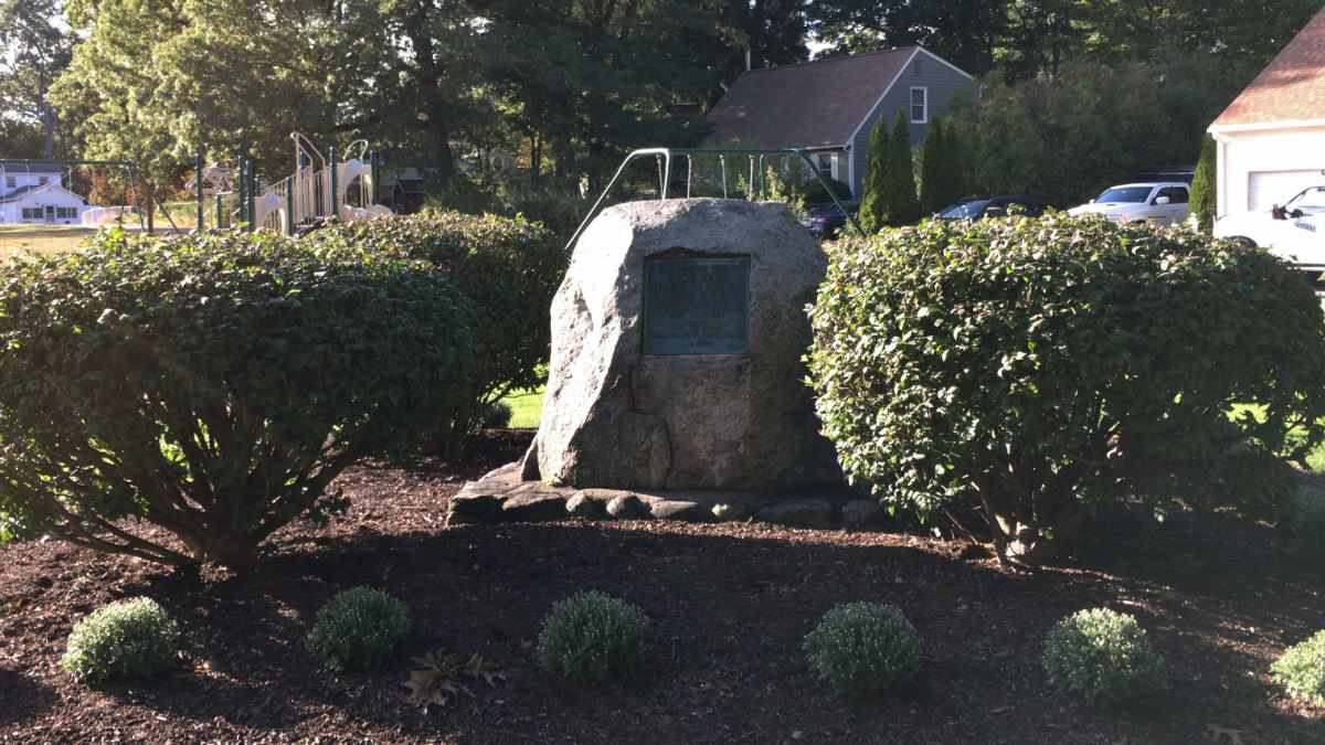
PermalinkThe Eames Massacre Monument
Monument to those that lost their lives in Framingham
In Framingham, near the corner of Chautauqua Ave and Mt. Wayte Ave, lies a monument to a horrific incident that occurred 340 years ago. In 1676, during King Philip's War, a mother and children were killed defending their home that was attacked by Indians.
This would be known as The Eames Massacre.
History of the Thomas Eames Family
In 1618, Thomas Eames was born in England. He came to Massachusetts Bay around 1634 and did some odd jobs. In 1637, he fought in the Pequot War.
After the Pequot war, Thomas married Margaret and settled in Dedham around 1640. They had three children John and Elizabeth. (The first John died before reaching age one.) Margaret died on September 17th, 1660.
In 1662, Thomas married Mary Paddleford and moved to Wayland. Mary was a widow and had four children from a previous marriage: Mary, Johnathan, Zachariah, and Edward. They had three additional children together: Thomas Jr., Samuel, and Nathaniel.
How they got the Framingham Farm
Thomas wrote a letter to the government of Massachusetts Bay and asked for land as a reward for his service in the Pequot War. His request was denied, but the request caught the attention of Deputy Governor Thomas Danforth. He gave a small part of his vast land to the Eames family.
The Eames farm was isolated from other families in the area. According to colonial document records, there were only seven families in the Framingham area. Most of the other family farms were together in the northern part of the town.
Tension between the Colonials and the Indians
King Philip's War (1675-1676) was an armed conflict between Native American inhabitants of present-day New England and the English settlers. The battle was seen as the last chance effort to remove the English settlers from New England.
In the summer of 1675, Massachusetts Bay provided four soldiers to secure the Framingham area. By the fall, there were no new attacks in the region, and the council in Boston couldn't justify the cost of the troops and decided to bring the troops back to Boston.
In January 1676, word got around that surrounding towns were at risk of being attacked by Indians. Thomas Eames took action and traveled to Boston to get ammunition and military help to protect his family.
February 1, 1676 - The Eames Massacre
While Thomas was away, eleven Indians attacked the house and farm. His wife Mary defended herself using hot soap. She was quickly overpowered and was killed along with five other children. The remaining children were taken into captivity and the house and barn were burned. Horses and livestock were stolen.
Results of the attack
| Mary Eames | 30 | Killed |
| Zachariah Paddleford | 18 | Captured and Escaped |
| Edward Paddleford | 15 | Killed |
| Thomas Eames Jr. | 12 | Killed |
| Samuel Eames | 11 | Captured and Escaped |
| Margaret Eames | 9 | Captured and Ransomed |
| Nathaniel Eames | 7 | Captured and Escaped |
| Sarah Eames | 5 | Killed |
| Lydia Eames | 3 | Killed |
Zachariah, Samuel, Margaret, Nathaniel all returned to Framingham after escaping from capture.
At the time of the attack, Thomas was very weak and on disability. It's possible that he could have been killed as a result of the attack.
Aftermath
Investigation into the attack and the identity of the Indians were uncovered: Netus, Anneweaken, Aponapawquin, Acompanatt, Panananumquis, William Wannuckhow, Apumatquin, Pumapen, Awassaquah, and Aquitekash.
Thomas Eames put together an inventory of the loss of items. The General Court granted him some monetary compensation for 200 acres of land as well as 200 acres of Indian land.
Much of the land become downtown Framingham and part of Ashland.
All the Indians that participated in the event were captured or were killed while trying to be captured. Some of the Indians were executed and others were sold off as slavery.
Thomas died in 1681 in Framingham, less than five years after the massacre.
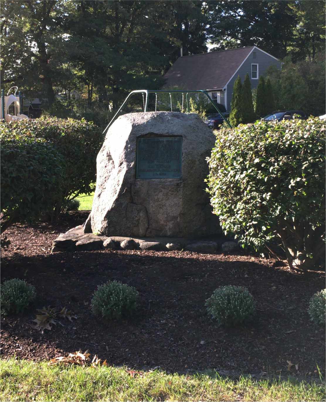
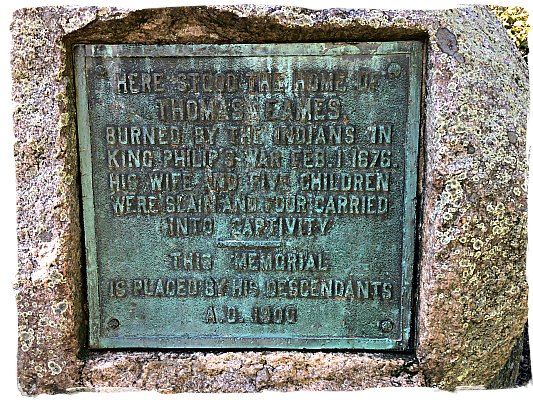
Rock Monument
In the early 1900s descendants of Thomas Eames put a rock monument at the location of the former homestead. The monument reads:
Here stood home of
Thomas Eames
Burned by the Indians In
King Philips War February 1, 1676
His Wife and Five Children
Were Slain and Four Carried
Into Captivity
This Memorial
Is Placed by his Descendants
A.D. 1900
Missing Sign
In 1930, another sign was placed on the site, just behind the plaque on the rock. It has since gone missing from the site.
The sign read:
"While Thomas Eames sought help from Boston on February 1st, 1676. The Indians attacked his house which stood nearby. His wife and five children were slain and four children captured."
Millwood Farms Golf Course
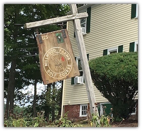
The town of Framingham currently has two golf facilities but only one is available to the general public. Framingham Country Club contains an 18 hole course available only to members and guests. The Millwood golf course is a 14-hole course that is privately owned but available to the public for a fee.
This will be the last year that Framingham will have two golf courses as the Millwood Farms Golf Course will have its final run in the next few weeks. Next year much of the golf course will be converted to a residential development and the remaining land will be a park. If you ever wanted to play golf at Millwood Farms, this is your last chance!
In May, the Drake Family agree to sell the 66-acre property for $5.5 million to the Capital Group Properties. The property was originally listed at $5.1 million in January. It looks like the Capital Group Properties is getting a good deal, last week I wrote how Framingham Franklin LLC was trying to sell a 6-acre strip mall for $5.5 million.
Special Town Meeting
Before the Drake Family could close on the deal, the town of Framingham had the opportunity to match the offer by the Capital Group Properties. This is because the land is zoned for farming and the town had given a tax break to the Drake family.
A special Town Meeting was held on September 1st with 155 town members showing up, representing .04% of the Framingham registered voters. The town voted to reject the purchase offer by a 69 to 86 vote.
The article required a 2/3 majority to pass. Which means that they needed 103 votes to approve the town to purchase the land.
The majority of registered voters rejected the purchase because there are a lot of upcoming capital purchases such as the millions of dollars worth of repairs to the Memorial Building, a renovation of Loring Arena and a school building project. To help persuade voters the developers had promised 30 acres that will be available to the public.
One group that tried to persuade voters to buy the land was the Framingham High School Golf team - as they have the opportunity to practice on the course for free. There's no indication of what will happen to the Framingham High School Golf team since they won't have a practice field.
The Capital Group Properties pledge to keep 30-acres as public land isn't in a legally binding document. The town of Framingham may have
Capital Group Properties
Some Miscellaneous Trivia on the Capital Group Properties.
- They are based in Southborough, Massachusetts
- They haven't disclosed exactly what they plan to build at the location but they indicate that it would be senior housing.
- Expect to submit the final building design to the Town Building committee in the next few months.
- Currently working on the Maynard Crossing project (About 9 miles north of Millwood Farms)
- Finished Mahoney Farms in Sudbury, MA 33 Condominiums on 30 acres
- Finished Mauro Farms, in Marlborough MA - 27 family homes
Millwood Farms Area History
Some people may not know that the Millwood Farms area actually has a historical past. There's plenty of history that goes all the way back to the early days of the revolutionary war.
The "Millwood Farms" area was once known as Millwood Flats and was acquired by the State of Massachusetts and developed into a recreation area.
In the 1670s the land belong, Governor Danforth, who got it from the land grants of the Massachusetts General Court. He sold a good portion of it to Colonel Joseph Buckminster. When the English colonies went to war during the Queen Anne's war, Buckminster became a captain in an expedition to French Acadia.
It was purchased in 1760 by Nathaniel Brinley. Nathaniel was a bit of a controversial figure in Framingham as people felt he was a Loyalist to the British. His name was on the "Address to Governor Gore" in 1775. The Inspection and Safety Committee took possession of the farm and sold it in an auction. (There's no record of who own the property between the Brinley and Bowditch's.)
In 1862, Ebenezer Francis Bowditch purchased the 600-acres estate when he was 21 years old. He names it Millwood Farm in honor of an old mill on the property. His paternal grandfather was Nathaniel Bowditch, the famous Salem mathematician and author.
Ebenezer Francis Bowditch married Elizabeth Fessenden Perry on March 2, 1864, and had four children: Nathaniel Bowditch, Annie Rodman Bowditch, Ebenezer Francis Bowditch, Elizabeth Francis Bowditch, and John Perry Bowditch. Nathaniel Bowditch would be the most well known of the children as he was the Framingham park commissioner
The Bowditch Mansion, where E.F Bowditch and Nathaniel Bowditch lived, now houses the Sudbury Valley School, on the corner of Millwood and Winch Streets.
In 1899 E.F Bowditch invited the 1st Brigade, Massachusetts Volunteer Militia to perform a realistic sham battle around the Millwood Farms area.
PermalinkMt Wayte Plaza
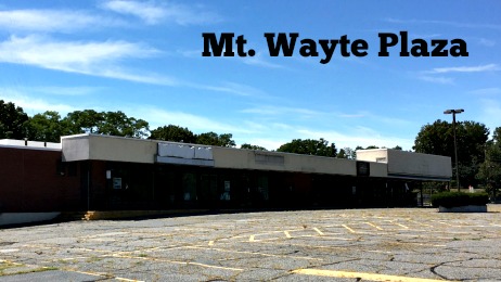
The Mt. Wayte Plaza is a dead strip mall at the corner of Mt. Wayte Ave and Franklin Street Framingham. The once thriving plaza is now mostly fenced in and since February 2015, has only one tenant. A few years ago the plaza owners promised local residents a complete redesign which would revitalize the area.
The official Address of the Mt. Wayte Plaza is 444 Franklin Street, Framingham MA 01702.
Current owner is Framingham Franklin LLC and managed by Samuel Adams, who father use to own the plaza.
Recent Mt. Wayte Plaza Timeline
- September 3, 2012 - Framingham Selectmen vote for a task force to see what can be done with the near-empty plaza. Emitted Domain is an option.
- December 6, 2012 - Samuel Adams gives a sneak peak of the designs to the Framingham planning board. The redesign estimate value at $10 million.
- March 6, 2014 - Developer formally asked for approval for redesign of Mt. Wayne Plaza project estimate is now $6 million
- August 7, 2014 - Framingham Planning Board unanimously approves Mt. Wayte Redevelopment Project
- December 23, 2014 - The Society of St. Vincent De Paul store closes and doesn't relocate elsewhere.
- February 23, 2015 - Dunkin Donut moves out of the Mt. Wayne Plaza
- February 28, 2015 - Dunkin Donuts opens at 430 Franklin Street (in front of the plaza)
- August 11, 2015 - Planning Board grants an additional six months to expand plaza.
- November 16, 2015 - Town Planning Board formally asks for the large blue signs to be removed.
- April 27, 2016 - Mt. Wayte Plaza is put up For Sale for $5.5 million
- August 6, 2016 - Planning Board complains about the lack of progress on the Plaza and unanimously votes not to extend the development permit.
Plaza Facts:
- 6.7 Acres For Sale for $5,500,000 (As of September 19, 2016)
- Property was assessed at $3.5 million in 2012
- Main Building is 53,000 square feet formerly occupied by Big D
- In 2012, there were rumors that Market Basket was going to move into the Plaza.
- There are 198 parking spaces in the current parking lot.
Stores that Use to be in the Plaza
- Big D / Price Chopper Supermarket October 1961 - April 2001
- IGA
- CVS
- Rob Roy Coiffure
- TCBY Yogurt
- Taylor Rental Center
- Optical Shop.
- Swimming Pool store
- Photomat
- Friendly Cleaners & Laundromat
- Jon Snow???s Shell Station
- O'Brien's Package Store 1998 - 2004
- St. Vincent de Paul Thrift Shop
- Dunkin Donuts
- Tony Maenzo Barbershop - Still there! It's the last business in the plaza.
What ever happened to the 400 Restaurant?
In 2007 the 400 Restaurant and Bar was re-opened into a quaint, neighborhood Italian-style restaurant. While the exterior still maintained its original charm and character, the inside was redecorated with the North End, trattoria-style design.
The 400 Restaurant closed its doors at the end of December 2013 because the owners, Bob and Amelia, were not able to secure a long-term lease.
Soon after the restaurant closed, Dunkin Donuts took down the building and put up a new Dunkin Donuts.
Dunkin Donuts vs Framingham Franklin LLC
According to local residents, there was a bit of a bad break up when Dunkin Donuts left the plaza. Immediately after they left new fencing was put up around the plaza to prevent Dunkin customers from parking in the nearly empty plaza.
Dunkin Donuts did have a bit of a hurdle opening their new locations, as the planning committee wasn't sure that there was enough parking for the anticipated morning traffic. This was partly due to the limited parking with the new fencing.
According to the aerial view, in 2013 the 400 Club had 21 parking spaces, whereas the new Dunkin Donuts has 17 parking spaces. 400 Club customers would park in the plaza when there were limited parking spaces.
Dunkin Donuts isn???t the first place to move out of the plaza and relocate nearby: O'Brien's Package Store did that back in 2004 and open next door, between the TD Bank and Convenient Store.
What could go in Mt. Wayte Plaza?
Just some thoughts...
How about converting the Jon Snow???s Shell Station to a Stop and Shop gas station or perhaps Cumberland Farms can open a gas station and future store? The could use the facility as a test market for their franchises.
The Plaza isn???t too far from Framingham State University, how about opening the first Amazon.com bookstore on the east coast?
Over the past few years, Micro Breweries seem to be the hot thing in Framingham. How about the newest microbrew restaurant: "A wonderful restaurant near downtown Framingham, Framingham Pale boasts one of the area's premier outdoor dining courtyards. A cross between New England tradition, Boston beer gardens, and a Revolutionary farm house, this truly is a unique destination."
PermalinkBowditch Field
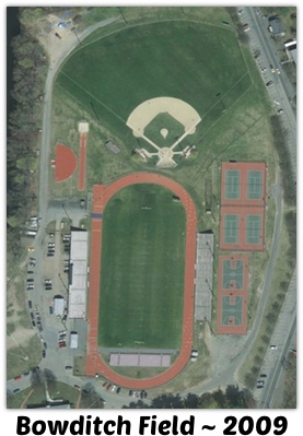
Bowditch field is a 18 acres athletic field in Framingham, Massachusetts. The field is home to the Framingham State University Rams football and baseball programs. The field also hosts football games from Framingham High as well as athletic events from Mass Bay. The complex is owned and operated by the Town of Framingham.
The field is located between Union Ave and Walnut Street in Framingham.
Current Amenities include Lighted NCAA regulation baseball diamond field, (4) Lighted Tennis Courts, Lighted Football, Lighted Outdoor Basketball, 0xBE Mile Jogging Area, 6-lane Track, Fitness Course with (20) Exercise Stations, Stadium Seating for 3,500 spectators.
Brief History of the Bowditch Field
The field was the town's "Fair Grounds" and had the first fair in 1869.
In 1917 the town of Framingham acquired the property from the South Middlesex Agricultural Society. At the time the land was used for horse racing and yearly agriculture fairs.
The stadium opened in the 1930s and was one of the Works Progress Administration projects during the Great Depression.
In 1946, the town of Framingham named the complex after Nathaniel Bowditch a long time park commissioner. ( It was not named after the mathematician Nathaniel Bowditch, who also wrote The American Practical Navigator.)
In 1959, 25,000 people gathered at Bowditch Field to celebrate Framingham's Jubilee Day. They gathered to celebrate the 50th anniversary of the Trust Company and the 100th anniversary of the Holliston's Hydrant Co. No. 3.
The complex last major renovation was in 2009 and a grand reopening was in October 2010. (The original opening was to be on September 15, 2010.) It cost the town $7.9 million. New stadium seats were added as well as a new concession was built.
In addition, a permanent monument was created near the entrance to highlight the history of the field.
Nathaniel I. Bowditch
Some brief information I found on Nathaniel I. Bowditch:
- Died on April 3, 1945 at 72
- Middlesex County Commissioner and founder since 1926
- Trustee of Massachusetts State College (now UMass)
- MIT Graduate
The Field today
Today most people use the running track as park of their daily exercise. The lights above the field are on every night until 11 pm. There are people that play team basketball until the lights go out.
Every Wednesday night in the summer the Framingham Running Club takes over the facility and conducts several races for kids of all ages. Ribbons are awarded for the first three runners that cross the finish line.
Metrofest has held its annual food truck event. The event features at least 20 food trucks, as well as activities for children, musical performances on two stages, and a tastings tent with craft beer, wine, and hard cider. The event as attracted some 13,500 guests to the Bowditch Athletic & Cultural Complex over the past few years
For one night in August, the town hosts a family movie night. People sit on the field and watch a movie on a large blow up screen. Past movie nights include The Lion King, Frozen and Zootopia.
Framingham High School Graduation and Commencement is held at the Bowditch field.
Parking is very limited with only 50 parking spaces in the immediate Bowditch field complex. The grass area, behind the concession stands, is open up during special events to accomodate more cars. There are some limited parking along Walnut street. Its highly recommend to arrive early for any major event.
Reservations Required
The public is invited to use the track when there are no events happening. The football field is off limits to the general public. If you are planning to have an event here, reservations are required. You can download an event permit from the Town of Framingham Park and Recreation website.
Pets are not allowed in the Bowditch field complex.
PermalinkFramingham MBTA Parking Spaces
New Parking at the Framingham MBTA Commuter Rail Station
The MWRA is in the early stages of building a new parking lot right next to the existing Banana lot in downtown Framingham. There will be an additional 250 parking spaces.
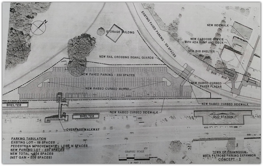
Once completed, there will be 417 parking spaces available for daily commuters to Boston.
The new lot will allow commuters to park much closer to the station.
Current Status
The MBTA is in the process of cleaning out the 'Y' field area. This was used as a holding area for the rail replacement that has been in process for the past couple of years.
 This Falll commuters will be watching construction of the Parking space.
Framingham Pearl Street Garage
A source at the Framingham Facilities Management has told me that they will not be making any changes to any of their commuter parking lots - including the nearby Pearl Street garage. There are no immediate plans to sell the garage or change parking fees.
The Pearl Street garage will still be the cheapest option for Framingham residences. The MBTA does offer a monthly permit for $70. The Pearl Street garage is only $65 for Framingham residents, non-residents pay $80 a month. However, having the MBTA monthly parking pass doesn't guarantee parking.
Last year the town tried to "gift" the lot to MassBay Community College as an incentive to move to downtown. This didn't work out as the State of Massachusetts didn't approve the necessary funding that MassBay needed to relocate.
There are no assign parking spaces in the garage. You are asked not to park in the basement.
Waverly Street Parking Lot
The Town of Framingham leases the lot across from the Commuter Rail station from the MBTA. This is commonly known as the Waverly Street Commuter Lot. I have learned that there is a waiting list for this lot because of its easier for commuters from Natick or Ashland to get in and out of. At $90 a month, this is a very expense lot, although some people pay $100 or more to park at various businesses near the West Natick Commuter Rail station.
Its uncertain if the new Banana Lot extension will fill up every day since some commuters will have to drive through downtown to get to the lot. Framingham traffic is very busy in the morning.
PermalinkAbout
Framingham is a city in the Commonwealth of Massachusetts. Every Tuesday I'll highlight something special about the city.
Check out all the blog posts.
Schedule
| Friday | Macintosh |
| Saturday | Internet Tools |
| Sunday | Open Topic |
| Monday | Media Monday |
| Tuesday | QA |
| Wednesday | New England |
| Thursday | Gluten Free |
Other Posts
- Mayor Yvonne M. Spicer
- Over the Air Signal in Framingham
- Plastic Bag Ban in Framingham
- The Framingham F
- Curbside Refuse Collection Planner
- Jordan’s Furniture Couches
- Melting Pot (Framingham)
- Cushing Memorial Park Children's Grove
- Saint Bridget Church Flags
- Dictograph Smoke Alarm
- Framingham Holiday Tree
- Massachusetts State Troopers Monument
- Shopper's World Track
- Hanson Farm
- Christmas Gala Music Selection